Age of Permanent Reclamation in the Oil Sands Region.png
Preview
Additional Information
| Field | Value |
|---|---|
| Format | PNG |
| URL | https://osmdatacatalog-uat.alberta.ca/dataset/b69a7174-5971-4b11-a084-23b0bb576f94/resource/d0f9e975-f33e-4ecb-946f-ff9966977b76/download/age-of-permanent-reclamation-in-the-oil-sands-region.png |
| Created | 4 November 2025 |
| Last Modified | 4 November 2025 |
| File Size | 17.52 KB |
| License | |
| Datastore active | False |
| Has views | True |
| Id | d0f9e975-f33e-4ecb-946f-ff9966977b76 |
| Mimetype | image/png |
| Package id | b69a7174-5971-4b11-a084-23b0bb576f94 |
| Position | 2 |
| State | active |
| Tracking summary | {'total': 0, 'recent': 0} |
| Url type | upload |
About the Dataset
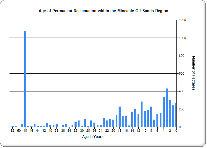
This data set identifies the amount of land across all oil sands mines that has been "permanently reclaimed", but has not yet been "certified" as reclaimed. It is based on the annual Conservation and Reclamation Reports submitted by the oil sands mine companies. This item is current to the end of 2023.
The definition of these terms (for the 2009 data and later) is as follows:
Permanent Reclamation (Terrestrial; Wetlands and Aquatics) – Land is considered permanently reclaimed when landform construction and contouring, clean material placement (as required), reclamation material placement and revegetation has taken place. Land cannot be listed under permanent reclamation until revegetation has occurred which is reflective of the approved Reclamation and Revegetation Plans.
Certified - Areas are certified that have received a reclamation certificate under the Environmental Protection and Enhancement Act. These areas are not counted in the Total Active Footprint calculation because they are no longer active; they are returned to the Crown.
View full dataset: Age of Permanent Reclamation in the Mineable Oil Sands Region